WP3 – “Regional groundwater modelling”
WP3: Impact of local transformation in the water system and land use on the regional groundwater flow
Leader: Dr. ir. Niko Wanders, Utrecht University
To fully understand the impact of a water transition towards a climate resilient water system which includes drastic landscape and water system changes, it is key to quantify the impact of these changes at landscape scale on the entire groundwater flow system. The regional groundwater system connects higher with lower areas, infiltration with discharge areas, groundwater with surface water interaction and provides a steering base for landcover functions like agriculture, nature, drinking water supply and living. Changes in landcover and water management have impact on the entire regional groundwater system and may have significant consequences on the groundwater dependent functions and should therefore be considered as one system. In a proof of concept where we simulate the impact of historical land use changes on groundwater levels in the Netherlands, we already show that the impact of changing landcovers and water management can be far reaching and results in up to a rise of 2m in groundwater levels (Figure 5). We know that the groundwater and surface water systems in the Netherlands are heavily intertwined and that most of the solutions for climate proofing the water system are focused on the intensively drained parts of catchments. Especially in these areas, groundwater – surface water interactions play a key role in controlling local and regional groundwater levels and catchment discharge dynamics, both during wet and dry conditions. The current drainage system is not climate robust and designed for fast discharge of the surplus of precipitation and lowering groundwater levels for agriculture purposes. A major challenge of the water transition is to redesign the drainage network to achieve higher spring and summer groundwater levels, increase the catchment base flow and decrease the risk of flooding. Climate change with expected wetter winters and drier summers makes this even more urgent. WP3 will enhance our understanding of the interaction between the land surface and the regional groundwater systems, by including better groundwater-surface water interactions in improved versions of the regional hydrological model of the Living Labs to evaluate the impact of landscape changes in the living labs. As part of this, WP3 will also study the impact of nature-based solutions and land use changes.
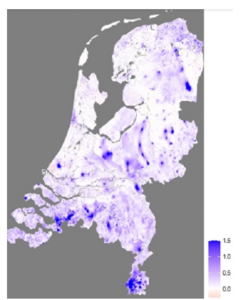
The impact on groundwater levels if we would revert land use back to 1900 conditions
The activities of this work package can be divided into four steps:
- Improved groundwater-surface water interactions in the regional groundwater models to better quantify the impact of changes in drainage network and water management on groundwater levels and catchment discharge. Including quantification of the impact of this modification in the modelling framework to reproduce groundwater levels and surface water levels at a national scale.
- Quantify the effects of climate change and current water management practices on (within and between year dynamics in) the water security of the future. With a specific focus on extreme drought conditions and the duration of recovery for these events, taking into account flooding conditions during wet periods.
- Quantify the impact of stakeholder actions and transformations in the landscape on the water security and exposure to future hydrological extremes.
- Incorporate knowledge in process-based tools to support policy making (Landelijk Hydrologisch Model) to serve the nation scale groundwater assessments.
Involved consortium partners:
Dr. Perry de Louw, Dr.ir. Gualbert Oude Essink

Prof. Marijke Huysmans

Prof.dr. Marc Bierkens

Dr.ir. Ruud Bartholomeus